|
VIEW FULL WINDOW MAPS CONTINUE SKIP BACKGROUND INFORMATION |
|
|
BACKGROUND INFORMATION by Wendall A. Phillips, ATC Radio Operator As the American Volunteer Group (AVG) was winding down, President Roosevelt was persuaded by pressure from China to do something to keep China in the war against Japan. The enemy had literally sealed off China from the rest of the world. Japan occupied all the sea ports and inland river and rail transportation routes by this time. Manchuria, Mongolia, Tibet and Burma were all occupied by the enemy. China was isolated and would be starved to death. The Chinese military was totally ineffective without supply (some say even with supply!). The Air Transport Command (ATC), Combat Cargo and Troop Carrier Command were all formed out of the U.S. Army Air Force, to begin to supply China and her military. When it was all said and done, millions of tons of materiel were flown over "The Hump" by the American Air Crews. In late 1944, the operation was flying mostly daylight and good weather. To increase tonnage, 24x7 operations were ordered and in the future, there would be no such thing as weather over The Hump !! Of course, the tonnage rapidly improved but, so did our losses in "Aluminum Alley," as we called it. The Hump became littered with our aircraft. On a clear day, you could see the sun reflecting off the wreckage of crashed planes lying there. We carried everything from millions of gallons of gasoline in 55-gallon drums to fuel air operations,to a full load of Kotex for the women!! Three mules to a load in a C-47 for pack animals for Merrill's Marauders in Burma and, just about anything else you can imagine. Another operation was moving Chinese troops to India for training and bringing them back later to re-join their army. CONTINUE |
|
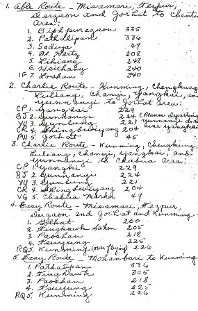
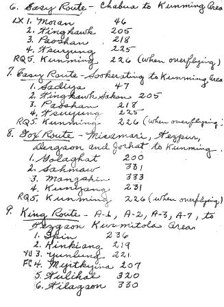
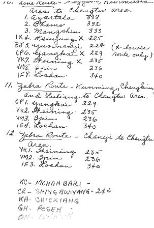
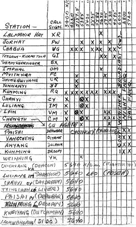
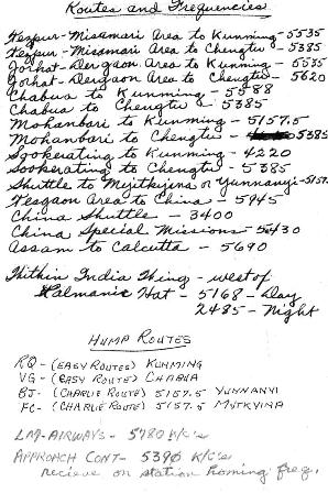
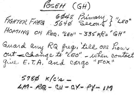
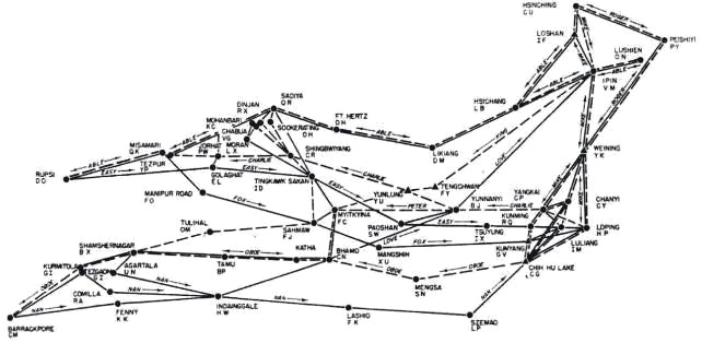
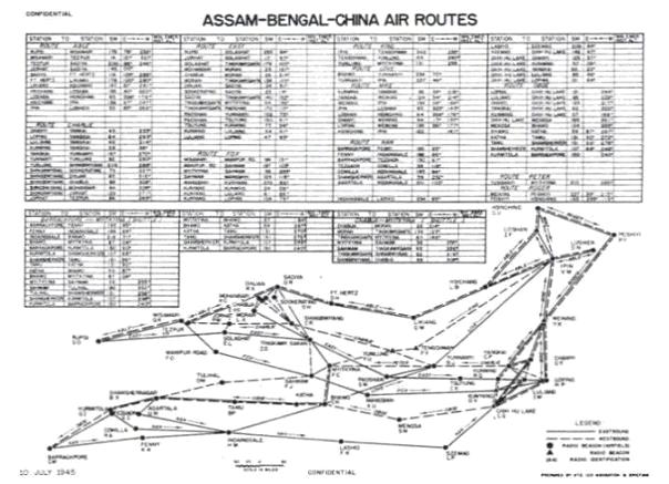
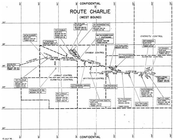
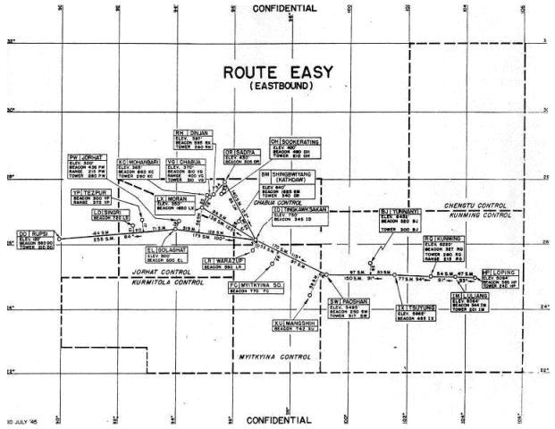
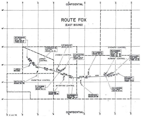
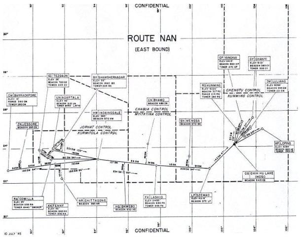
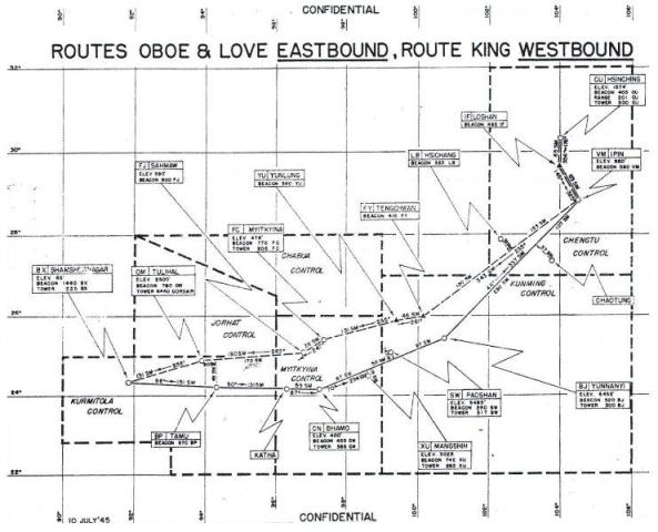
ABOUT THE MAPS AND RELATED PAGES The first map shown is an overlay of all of the main routes to and from the great many airfields that we served in the theater. The other maps, Charlie Route, Easy Route, Fox Route, Nan Route, Oboe, Love, and King Routes provide detail for the pilots, including Airbase Name, Runway Elevation, Radio Contact Frequencies, and Beacons for landing, if any. Directional headings in detail from place to place are also furnished on these detail maps. Much of the mapping was derived from Pan American pilots who flew by the "seat of their pants" before the war as they set up the original airline routes in most of the world. We only expanded upon that information as we needed. The hand written pages were part of a little notebook carried by radio operators in the leg (shin) pocket of our flight cover-alls. It defines the radio contacts by frequency, as the pilots navigate their route. Pilots could not take an aircraft off the ground without a Radio Operator. Being very detail oriented all of my life, I was, even as a young man, generally prepared for any occasion in my performance of duty! Radio operators and two pilots were the only crew. I am very friendly even now with several of my old pilots and they will tell you that when they were totally lost in bad weather, etc., their radio man saved their lives by radio navigation. I am proud of those several pages I was able to save! It is my handwriting and printing from 1944 and 1945, when I was only about 21 years old! As for the operation of any flight... the pilots would go to a briefing and call for a radio operator later. They would give us the information of what route we would fly and the station(s) we would be landing along the route. It was up to the radio operator to maintain radio monitoring along the way and keep the pilots informed as the plane passed certain beacons and any aircraft communications that might be heard in the air space. You may not see them but, radio would come in loud and clear! With my 116 "Hump" trips, God certainly was looking after me.
|
CONTINUE |

CLICK TO EXPAND CONTINUE |
CLICK TO EXPAND CONTINUE |
CLICK TO EXPAND CONTINUE |
CLICK TO EXPAND CONTINUE |
CLICK TO EXPAND CONTINUE |
CLICK TO EXPAND CONTINUE |
|
ROUTE INFORMATION NOTES
|
CONTINUE |
|


Assam-Bengal-China Air Routes China-Burma-India Theater of World War II Maps and Information provided by USAAF CBI Veteran Wendall A. Phillips Copyright © 2006 Carl Warren Weidenburner BACKGROUND INFORMATION ROUTE INFORMATION NOTES HUMP ROUTE GUIDE CHARLIE EASY FOX NAN OBOE-LOVE-KING TOP OF PAGE FULL WINDOW MAPS WENDALL A. PHILLIPS CHINA-BURMA-INDIA THEATER |